
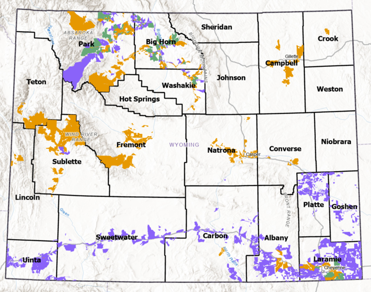
The Wyoming Broadband Office (WBO) is working with state, federal, tribal, local, and private permitting partners to support the timely deployment of broadband infrastructure funded through the Broadband Equity, Access, and Deployment (BEAD) Program. Sixty-one projects, awarded to ten providers, will bring service to 32,361 locations across the state. Together they represent approximately $244 million in combined award and matching investment.
A single project route in Wyoming can cross the jurisdiction of many permitting authorities, including state highways, federal lands, tribal lands, rail corridors, and county and municipal rights-of-way. WBO has established a recurring series of permitting roundtables and working sessions to help these projects move through review efficiently and fairly.
Program at a glance
As of September 30, 2026
Measure | Value |
Projects selected | 61 |
Awardees (providers) | 10 |
Awards with executed contracts | 49 |
Awards with contract extensions | 12 |
Total BEAD awards | $182.2 million |
Matching funds | $61.6 million |
Combined investment | Approximately $244 million |
Broadband serviceable locations | 32,361 |
Because ten providers are delivering sixty-one projects, a single provider may submit applications across multiple districts and jurisdictions. All awardees are working against the same federal deadlines, so permitting partners should expect applications to arrive in clusters rather than evenly over time.
In accepting its BEAD award, the State of Wyoming agreed to four expanded permitting obligations. They are set out in the state’s Notice of Award and in Section 13D of NTIA’s BEAD General Terms and Conditions.
These are commitments made by the State of Wyoming. They are not new mandates on permitting agencies. WBO can meet them only with data and cooperation from its permitting partners, which is why the roundtable program exists.
| Obligation | What it means | How WBO supports it |
|---|---|---|
| Permit application expediency | Broadband permit requests are approved or denied within 90 days | Working with partners to establish clear workflows, checklists, and points of contact, and to identify where the 90-day window is and is not realistic |
| Minimizing permitting costs | Seeking to reduce the cost of permitting for broadband deployments | Monitoring costs and encouraging fair and reasonable permitting costs |
| Permitting roundtables | Convening permitting authorities on a recurring basis | Hosting quarterly roundtables and staff-level working sessions for the duration of the program |
| Tracking and reporting | Tracking and reporting permitting compliance issues | Tracking issues and publishing a semi-annual public report on the WBO website |
How permitting coordination works
WBO compares each subgrantee’s project routes against official data layers provided by permitting partners. This analysis identifies potential permitting impacts (PPIs). A PPI is a location where a project route intersects an area under a partner’s jurisdiction or a sensitive resource.
A PPI is a flag, not a confirmed permit requirement. Some will turn out to require no action. WBO takes a deliberately broad approach so that partners are not surprised later in the process.
Step | What happens |
1. Route analysis | Subgrantee project routes are analyzed against partners’ official GIS data layers |
2. PPI identification | Intersections between routes and partner data layers are flagged as potential permitting impacts |
3. Subaward kickoff meeting | WBO convenes a permitting kickoff meeting for each subaward to review requirements, establish points of contact, and communicate anticipated timelines |
4. Issue tracking | WBO tracks permitting issues, roundtable topics, and subgrantee compliance issues, and works with partners to streamline resolution |
5. Public reporting | WBO posts a public report on its website, updated at least twice a year |
The data below was created by analyzing high level designs from subgrantees with publicly available GIS data to determine an estimate of impact.
| Permitting authority | PPIs | Miles |
| County rights-of-way | 9,975 | 1,777.29 |
| Wyoming Department of Transportation | 2,102 | 676.05 |
| US Bureau of Land Management | 258 | 133.26 |
| US Forest Service | 389 | 184.56 |
| Tribal lands | 1,347 | 160.40 |
| Municipal rights-of-way | 1,409 | 97.92 |
| US Army Corps of Engineers | 31 | 4.77 |
| Railroads | 325 | 86.56 |
| US National Park Service/ National Register of Historic Places | 255 | 40.12 |
| US Fish and Wildlife Service | 4,330 | 119.03 |
| US Department of Defense | 3 | 0.58 |
| US Bureau of Reclamation | 1,288 | 207.32 |
Roundtables and working sessions
Permitting coordination runs on two tiers. Quarterly roundtables bring together agency leadership. Working sessions are for the staff who process applications. Both are closed to the public so that participants can speak candidly about process challenges. The program’s outputs, including meeting minutes and resources, are made available afterward.
| Quarterly permitting roundtables | Permitting working sessions | |
| Participants | Agency directors or designated representatives, the WBO team, and relevant subject matter experts | Staff who process permit applications, the WBO team, subject matter experts, and BEAD subgrantees |
| Frequency | Quarterly: November, February, April, and July | Held as needed between quarterly roundtables |
| Purpose | Progress updates, issue escalation, and program-level coordination | Practical, topic-specific problem-solving |
| Public access | Closed to the public | Closed to the public |
| What is published | Meeting minutes following each roundtable | Resources shared via email or posted to website as appropriate |
| Begins | November 2026 | December 2026 |
The roundtables serve three purposes. They surface issues early, resolve them at the lowest level possible, and keep permitting from becoming the schedule driver for sixty-one projects moving at the same time. They are also the forum where WBO shares route changes, subgrantee timelines, and resources with partners.
Schedule
| Date | Session | Focus/Post Event Materials |
| October 2026 | Introductory session – Permitting Partners | Slide Deck, Meeting Minutes |
| October 2026 | Introductory session – NTIA | Slide Deck |
| November 2026 | Q4 roundtable | Progress update |
| December 2026 | First working session | Topic to be confirmed based on partner input |
| February 2027 | Q1 roundtable | Quarterly progress and issue escalation |
| April 2027 | Q2 roundtable | Quarterly progress and issue escalation |
| July 2027 | Q3 roundtable | Quarterly progress and issue escalation |
| 2027–2030 | Ongoing | Quarterly roundtables continue for the duration of the program |
Potential deep-dive topics
WBO may offer focused sessions on topics that cut across multiple projects. Partners are encouraged to suggest additional topics.
The permitting roundtables include a broad cross-section of Wyoming’s permitting community:
If your organization issues permits or conducts reviews for linear infrastructure in Wyoming and is not yet involved, please contact WBO.
1. Contact information for all designated points of contact. A person, not a general inbox — plus a second name if the staff member who attends working sessions differs from your director-level representative. If there is an applicable permitting authority WBO has not yet identified, please tell us who it is.
2. GIS files of your official data layers. Used for the potential permitting impact (PPI) analysis that tells each agency where BEAD routes touch its jurisdiction. Submit files directly or send links for file download.
3. Communication of concerns or issues with BEAD subgrantee projects. Early notice costs everyone less than late notice.
4. Resource documentation to share with subgrantees. Application checklists, submission guides, fee schedules, timeline expectations, seasonal restriction calendars.
Permitting inbox: [email protected] — for contact submissions, GIS data layers, project concerns, resource documentation, and permitting issue escalation.
Staff: Chad Bolling, Wyoming Broadband Manager
The information on this page, including project counts, funding figures, project routes, maps, and potential permitting impacts, is provided for general informational and planning purposes only. It reflects high-level data available to the Wyoming Broadband Office (WBO) as of the date shown and is not a final, engineered, or survey-grade representation of any BEAD project.
BEAD project data will be updated and will change throughout the life of the program. Project routes, construction methods, mileage, locations served, and associated permitting impacts may change as subgrantees complete engineering design, obtain permits, and begin construction. Contract status and funding figures may also change as awards are finalized or amended.
WBO makes no representation or warranty regarding the accuracy, completeness, or currency of this information. It should not be relied upon for engineering, construction, legal, or permitting decisions. Permitting authorities retain full responsibility for determining whether a permit or review is required for any project within their jurisdiction.
To report an error or ask a question about this data, contact [email protected].